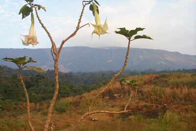
 This is the
view from Upper Farms towards the summit of Mt. Cameroon; the start of the hike
was about 7AM. During the dry season, mornings often provide clear views
of the mountain and the surrounding areas.
This is the
view from Upper Farms towards the summit of Mt. Cameroon; the start of the hike
was about 7AM. During the dry season, mornings often provide clear views
of the mountain and the surrounding areas.Big Hike
This is the
view from Upper Farms towards the summit of Mt. Cameroon; the start of the hike
was about 7AM. During the dry season, mornings often provide clear views
of the mountain and the surrounding areas.
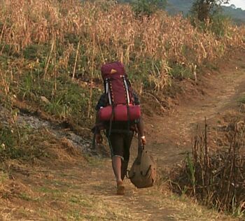 Here is a
photo of one of our porters. The big pack is Steven's, and I think he is
carrying a second pack on his chest. The third pack is the porter's that
contains food and water for himself. The trail is not too steep yet, but
it gets worse.
Here is a
photo of one of our porters. The big pack is Steven's, and I think he is
carrying a second pack on his chest. The third pack is the porter's that
contains food and water for himself. The trail is not too steep yet, but
it gets worse.
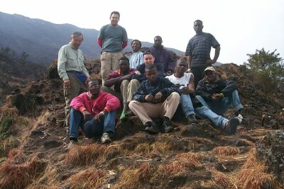
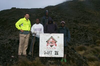
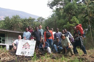 Here is the
motley crew at Hut 1. Everyone still looks fresh and happy, of course it
is only 9AM with 3000ft yet to climb! Not everyone in the picture was in
our hiking party, but they were also on the trail that day.
Here is the
motley crew at Hut 1. Everyone still looks fresh and happy, of course it
is only 9AM with 3000ft yet to climb! Not everyone in the picture was in
our hiking party, but they were also on the trail that day.
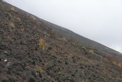
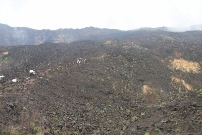 This is the
lava field that you see as you exit the savannah and start the serious ascent.
There is not really a clear, demarcated trail; people just pick their way up the
slope. This was one of many disheartening views as we struggled to get to
Hut 2.
This is the
lava field that you see as you exit the savannah and start the serious ascent.
There is not really a clear, demarcated trail; people just pick their way up the
slope. This was one of many disheartening views as we struggled to get to
Hut 2.
 Here is a
visible example of the slope that we encountered along the way. Most of
the trail between Hut 1 and Hut 3 looks similar to this or worse. There
are no good stopping places to rest, so you just sit where you want to catch
your breath before continuing.
Here is a
visible example of the slope that we encountered along the way. Most of
the trail between Hut 1 and Hut 3 looks similar to this or worse. There
are no good stopping places to rest, so you just sit where you want to catch
your breath before continuing.
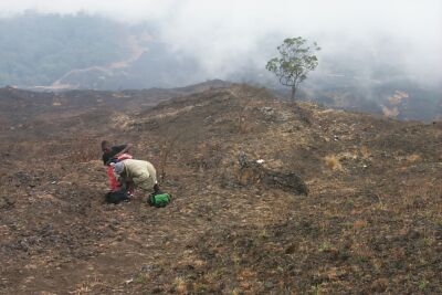 This is
the view from above the "magic tree" looking back towards the savannah and Hut
1. As you can see, the hill falls off rather steeply, and there is no
other vegetation around to provide shade for a brief respite. Even though
the tree provides a point of reference, you can see that the terrain does not
change much to provide relief for weary hikers.
This is
the view from above the "magic tree" looking back towards the savannah and Hut
1. As you can see, the hill falls off rather steeply, and there is no
other vegetation around to provide shade for a brief respite. Even though
the tree provides a point of reference, you can see that the terrain does not
change much to provide relief for weary hikers.
 This is our
hiking group after reaching Hut 2. The back row consists of Tom, Steven,
Christine, Fred, and one of the porters. In the foreground, Daniel (red
coat) and Christof (blue baseball hat) can be seen amongst our other hiking
companions. We felt pretty optimistic about our progress and our chances
for reaching the summit.
This is our
hiking group after reaching Hut 2. The back row consists of Tom, Steven,
Christine, Fred, and one of the porters. In the foreground, Daniel (red
coat) and Christof (blue baseball hat) can be seen amongst our other hiking
companions. We felt pretty optimistic about our progress and our chances
for reaching the summit.
 After four more
hours of hiking, the summit team reached Hut 3. This is the view after
cresting the last of 5 continuous climbs. The summit you see is a fake
summit; the Guinness summit is off to the right about 1 mile from Hut 3.
After four more
hours of hiking, the summit team reached Hut 3. This is the view after
cresting the last of 5 continuous climbs. The summit you see is a fake
summit; the Guinness summit is off to the right about 1 mile from Hut 3.
. Here are a
few of the weary survivors of the climb to Hut 3. You can see that the
altitude and temperature affects Cameroonians differently than they affect
Steven. They had been cold for most of the climb up to Hut 3 and required
coats and headgear, but Steven just needed a windbreaker in the 5 degree Celsius
alpine environment.
Here are a
few of the weary survivors of the climb to Hut 3. You can see that the
altitude and temperature affects Cameroonians differently than they affect
Steven. They had been cold for most of the climb up to Hut 3 and required
coats and headgear, but Steven just needed a windbreaker in the 5 degree Celsius
alpine environment.
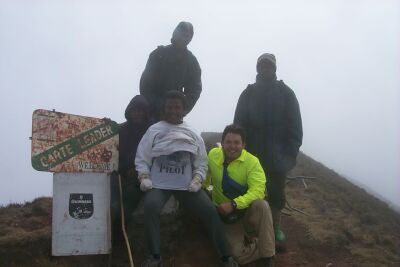 This is the
same group as in the previous picture but finally at the summit. The
clouds and wind created a white-out condition, so visibility was quite poor.
The hope was that we would be able to see much of the countryside below, but the
weather did not cooperate. You can still read, however, Christine's
t-shirt (pilot); she is the first and only woman pilot for Cameroon Airlines.
Maybe her subsequent trips to the summit will involve a method of air transport
instead of hiking?!
This is the
same group as in the previous picture but finally at the summit. The
clouds and wind created a white-out condition, so visibility was quite poor.
The hope was that we would be able to see much of the countryside below, but the
weather did not cooperate. You can still read, however, Christine's
t-shirt (pilot); she is the first and only woman pilot for Cameroon Airlines.
Maybe her subsequent trips to the summit will involve a method of air transport
instead of hiking?!
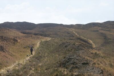 This is an
example of the trail as we descend from the summit. It seems to meander up
to the edge of the steep decline, and then drop precipitously to the savannah
and farm land below. There are a few alpine flowers, grass, and lichen,
but little else. As an example of the unforgiving setting, one of the
runners in the race up Mt. Cameroon died near this section of the trail.
Disobeying doctor's orders, the runner decided to try the climb anyway; he got
tired and lay down to get some sleep, but he never awoke.
This is an
example of the trail as we descend from the summit. It seems to meander up
to the edge of the steep decline, and then drop precipitously to the savannah
and farm land below. There are a few alpine flowers, grass, and lichen,
but little else. As an example of the unforgiving setting, one of the
runners in the race up Mt. Cameroon died near this section of the trail.
Disobeying doctor's orders, the runner decided to try the climb anyway; he got
tired and lay down to get some sleep, but he never awoke.
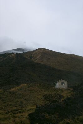
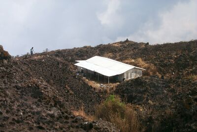 This was our
vision of hope as we descended from Hut 3 to Hut 2. The trail descends
from Hut 2 off to the left. As one might guess, there are numerous caves
or caverns that go down into the mountain, providing an underground tunnel
system formed by volcanic activity. The guide and porters told us that
many bats lived down there, but none of us brought a torch to investigate.
This was our
vision of hope as we descended from Hut 3 to Hut 2. The trail descends
from Hut 2 off to the left. As one might guess, there are numerous caves
or caverns that go down into the mountain, providing an underground tunnel
system formed by volcanic activity. The guide and porters told us that
many bats lived down there, but none of us brought a torch to investigate.